Pennine Way 2013
Monday 22nd April 2013 – Forest in Teesdale to Dufton
The forecast was gloomy for our hike out of County Durham into Cumbria: dull and windy, with the prospect of more rain as we headed west. Jean fixed an excellent breakfast and packed lunch, and we walked away in our waterproofs, hats and gloves just as the children were going inside the nearby school. Resuming our trek beside the Tees, we didn’t see the best of this remarkable section of the Way because the weather sulked on us.
Crossing the soggy pastures we faced a stiff wind but, thankfully, no rain. Beyond Widdybank Farm, the Tees runs shallow in a wide and stony channel where the hills close in and the dolerite cliffs of Falcon Clints rise on the right. This is a glorious lonely valley, with few sounds but the chatter of the river, and I love it.
The route beside the river is rocky in parts and also prone to flooding. Much of the path used to be an unedifying squelchy slog that tested patience and endurance, especially for those walking the whole distance between Middleton and Dufton in one day. Now it’s easier, thanks to duckboards and paving. Whilst such human interventions are welcome to me, I shall forever condemn the decision to construct the ghastly dam that impounds Cow Green Reservoir, flooding the head of the grandest valley in the Pennines.
We took a brief rest before climbing the rocks beside Cauldron Snout, one of the very few places on the Way (stiles excluded) where two hands are needed. The wind gusted wildly at the top, scattering spray across our path. We headed into the gale on the broad vehicle track that ends at the farm of Birkdale. Helen tucked in behind me for shelter, and thus we progressed all the way across the moor to the edge of the Eden Valley.
It wasn’t the sort of day I’d hoped for, but we don’t grumble. Here I pay tribute to Helen’s strength as a walker and an uncomplaining companion on the hills, regardless of the conditions. She meets my specification in that she can walk twenty miles across rough country, and I think I meet hers in that I usually find the way.
On this day, we each drew on our respective strengths as the wind increased and blew low cloud and stinging drizzle in our faces. Visibility reduced to about twenty metres, so I referred to the compass whenever we came to what looked like a split in the path. We crossed the new footbridge high above Maize Beck to walk a pleasant grassy path to the cloud-shrouded landmark of High Cup Nick, from where we saw absolutely nothing of what is arguably the most stunning view on the Pennine Way. Just as at Malham Cove, so too at High Cup… Oh well, some other time…
Way back then… When the Pennine Way was first discussed, much was made of the remoteness of this Pennine crossing. On 1st September 1963 we walked from Middleton to Dufton. Scenically, it was our best day, and the weather was superb. Crossing the moor from Birkdale was a boggy experience, but we were so fit and full of adrenaline we ploughed on without slackening our pace until we were brought to a standstill by the magnificent spectacle of High Cup, its dolerite crags and huge U-shaped scoop of a valley, the Vale of Eden below and the Lake District mountains far beyond. As we gazed in wonder, wraiths of mist began forming around us. That was an unforgettable day. When we walked into Dufton, looking for Dufton YH, we were told it was in the village of Knock, so we had another couple of miles to race in time for dinner. Hey ho! We made it!
Descending in welcome sunlight, we stopped for a snack, our lunch break having been very brief in the gale on Birkdale Moor. When we found that The Stag Inn would not provide meals that night, we phoned for a taxi to Appleby, where we ate and drank very well indeed at the award-winning Royal Oak.

Falcon Clints
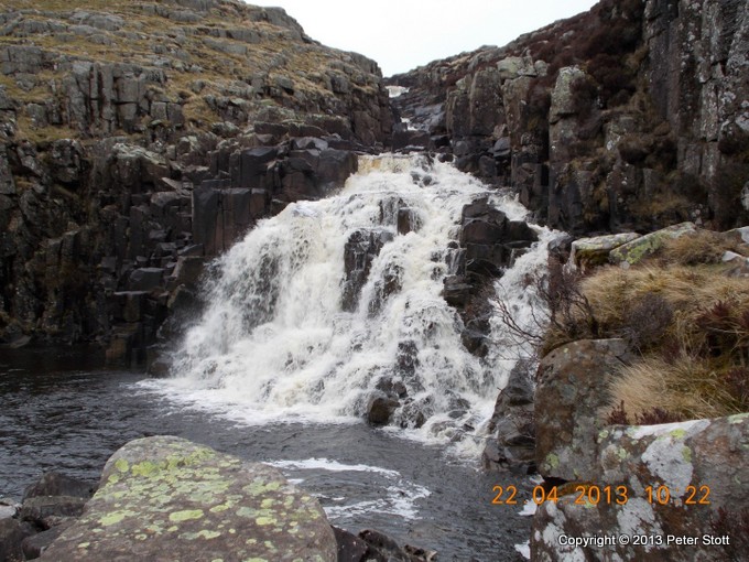
Cauldron Snout: the Way climbs the rocks on the right
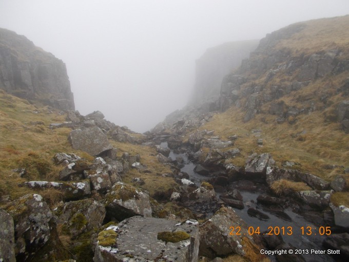
High Cup Nick, where the views can be stupendous – honest!